Malaysia Petroleum Management

-
Overview of Exploration in Malaysia
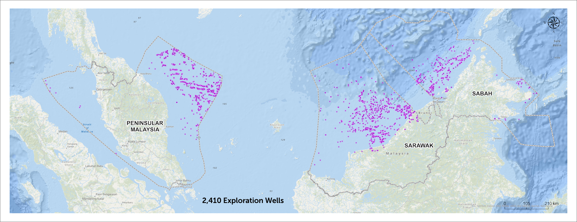
In the last fifty years of exploration in Malaysia, MPM has overseen the drilling of over 2,400 exploration wells, leading to the discovery of around seven billion barrels of oil and 75 trillion cubic feet of gas of commercial quantities. With robust pipeline infrastructure in place, Malaysia has produced approximately 13 billion barrels of oil equivalent from these discoveries. Nevertheless, the country’s prolific basins still offer new play potentials that require exploration efforts to unravel.
- Malaysia Basins
- Remaining Potential
- Data Enrichment & Enhancement
- PETRONAS myPROdata
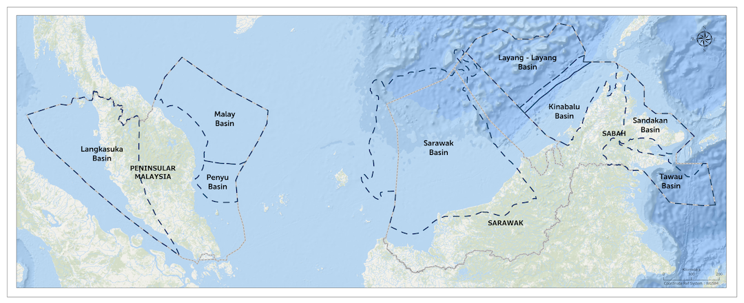
There are a total of eight basins that feature a range of geological play types, spanning from shallow to deepwater. Currently, three of these basins—Malay Basin, Sarawak Basin, and Kinabalu Basin—are producing hydrocarbons. The remaining five (5) basins include Langkasuka Basin, Penyu Basin, Layang-Layang Basin, Sandakan Basin, and Tawau Basin are considered frontier basin.
Malaysia’s mature basins continue to yield significant oil and gas discoveries, with recent finds such as Silungen1 in Sarawak, Zoisit Deep-1 in Kinabalu, and Bekok Deep-1 in Malay Basin. These recent discoveries underscore the abundant potential of Malaysia's basins, with the bulk of resources expected to be in the frontier area.
Frontier Basins
Langkasuka Basin
Langkasuka Basin refers to the Pre-Tertiary sedimentary basin underlying Selat Melaka. Langkasuka Basin covers an area of 759,000 km2 encompassing parts of North West (NW) Sumatra in Indonesia, Western Peninsular Malaysia as well as Peninsular Thailand.
The Langkasuka Basin, located at the southernmost part of the Sibumasu terrain was connected to the Gondwana supercontinent from the Paleozoic to Mesozoic. During Permian Period, the Sibumasu Terrane rifted, drifted, and subducted into the Indochina block, forming the Langkasuka Basin in the Late Triassic to Jurassic Period. This basin is emerging as a promising frontier, analogous to the Canning Basin in NW Australia. Exploration in the 1970s initially focused on the Tertiary level, yielding positive hydrocarbon indications. The discovery of Singa Besar-1 in the Permian prompted further exploration by MPM into the deeper Pre-Tertiary section.
Penyu Basin
The Penyu Basin is an extensional basin in central Sundaland, located offshore of eastern Peninsular Malaysia. This basin trends east-west direction, spanning 18,500 km² of area with sediment thickness up to 9 km with water depths ranging from 15m to 80m.
Penyu Basin, the 'third sister' basin alongside the Malay Basin and the West Natuna Basin, remains underexplored with only 17 exploration wells drilled to date. Since 1970s, exploration efforts have primarily targeted structural traps within the Tertiary reservoirs. The discoveries of Rhu-1 and Janglau-1 have confirmed the presence of a working petroleum system.
The reactivation of exploration efforts in the Penyu Basin consist of 2D & 3D imaging enhancements, integrated studies, and multiclient 3D seismic acquisition. While there are remaining untested potential within the Tertiary section, a renewed perspective on future exploration targets has expanded to include the new play potential from deeper Pre-Tertiary sections.
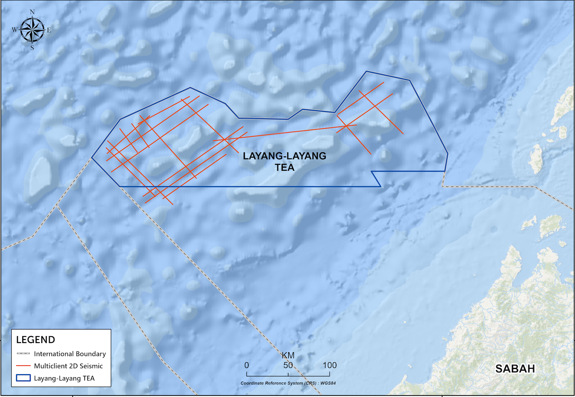
Layang-Layang Basin
Layang-Layang Basin, colloquially known as Northwest Sabah Platform, is located in Dangerous Ground area. It is named after Layang-Layang Island, lies some 300km northwest of Kota Kinabalu, Sabah.
The basin trends NE-SW, covering an area over 76,000 km2. The southeastern limit, where the Oligo-Miocene carbonate play extension presents, is overlaid by toe-thrust fold area of Kinabalu Basin.
The discovery of Tepat-1 in Oligo-Miocene carbonate play proved the effectiveness of a working petroleum system in the basin. Positioned as a key frontier for growth, Layang-Layang Basin offers hydrocarbon potential that is comparable to major discoveries in NW Palawan Basin such as Malampaya and Sampaguita fields. Ayam Hutan prospect is targeting multiple proven play segments: Paleogene Syn-rift Clastics & Carbonate and Paleogene Prerift Carbonate play, potentially holds up to 7 Tcf gas in-place (P50).
New 1,600 line-km MC2D was acquired and the MC Study embark in January 2025.
Sandakan Basin
Sandakan Basin, situated in Northeast Sabah, is classified as a passive margin basin. It spans a vast area of approximately 34,000 km², encompassing both onshore and offshore areas, with sediment thickness reaching around 8,000 metres. The basin is bordered to the north by the Cagayan or Keenapusan Volcanic Ridge, to the south by the Sulu Volcanic Ridge, and to the southwest by the Borneo hinterland.
Over the past decades, several operators have conducted exploration activities, leading to significant discoveries in the Sebahat Miocene plays. Five major fields—Nymphe North, Nymphe, Benrinnes, Kuda Terbang, and Mutiara Hitam—are now ready for development to meet the demand in East Sabah.
There remains significant potential for exploration of diverse hydrocarbon plays, including Pliocene, Miocene, and Oligocene Clastic plays, as well as Carbonate plays from the Miocene and Oligo-Miocene ages.
Tawau Basin
Tawau Basin, located in Southeast Sabah and covering around 40,000 km², separated from the Sandakan Basins by the Sulu Plateau.
Exploration activities in the Tawau Basin have been ongoing for over a century, beginning with the first well drilled in 1912 by Bataafsche Petroleum Maatschappij (BPM) in the northwest of Sebatik Island, which reported a minor sand trace oil. Numerous surveys to enhance subsurface imaging have been acquired and wells have since been drilled to evaluate hydrocarbon potential.
The basin encompasses a diverse array of proven plays, including Miocene and Intra Pliocene Clastic plays in the southern region, which comprising Miocene to Eocene Clastic, Oligocene Carbonate, and Pre-Tertiary Basement. Structural deformation has led to the creation of rifting and deepwater toe thrust formations with unexplored stratigraphic traps.
The basin is part of the greater Tarakan Basin with hydrocarbon reserves nearing 500 MMboe from nearby proven fields, including the Badik, Aster and Tulip Fields. With its extensive variety of play types and considerable resource potential, the Tawau Basin remains a vital asset for meeting Malaysia's energy requirements and driving economic growth.
Data as of 1 January 2025
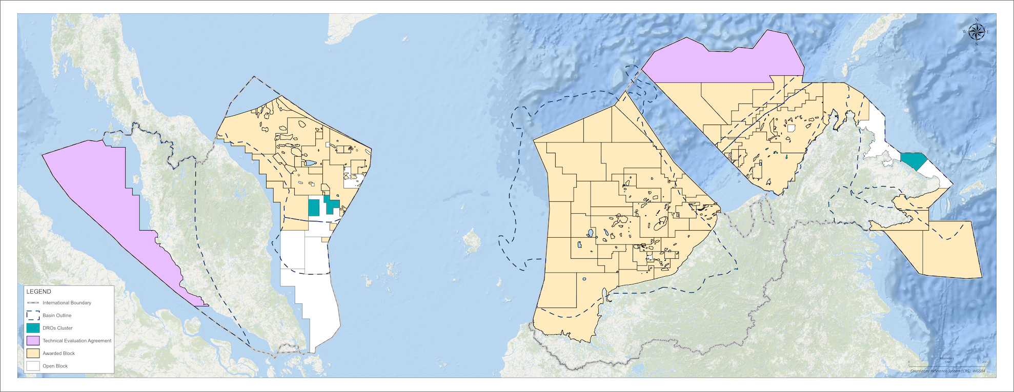
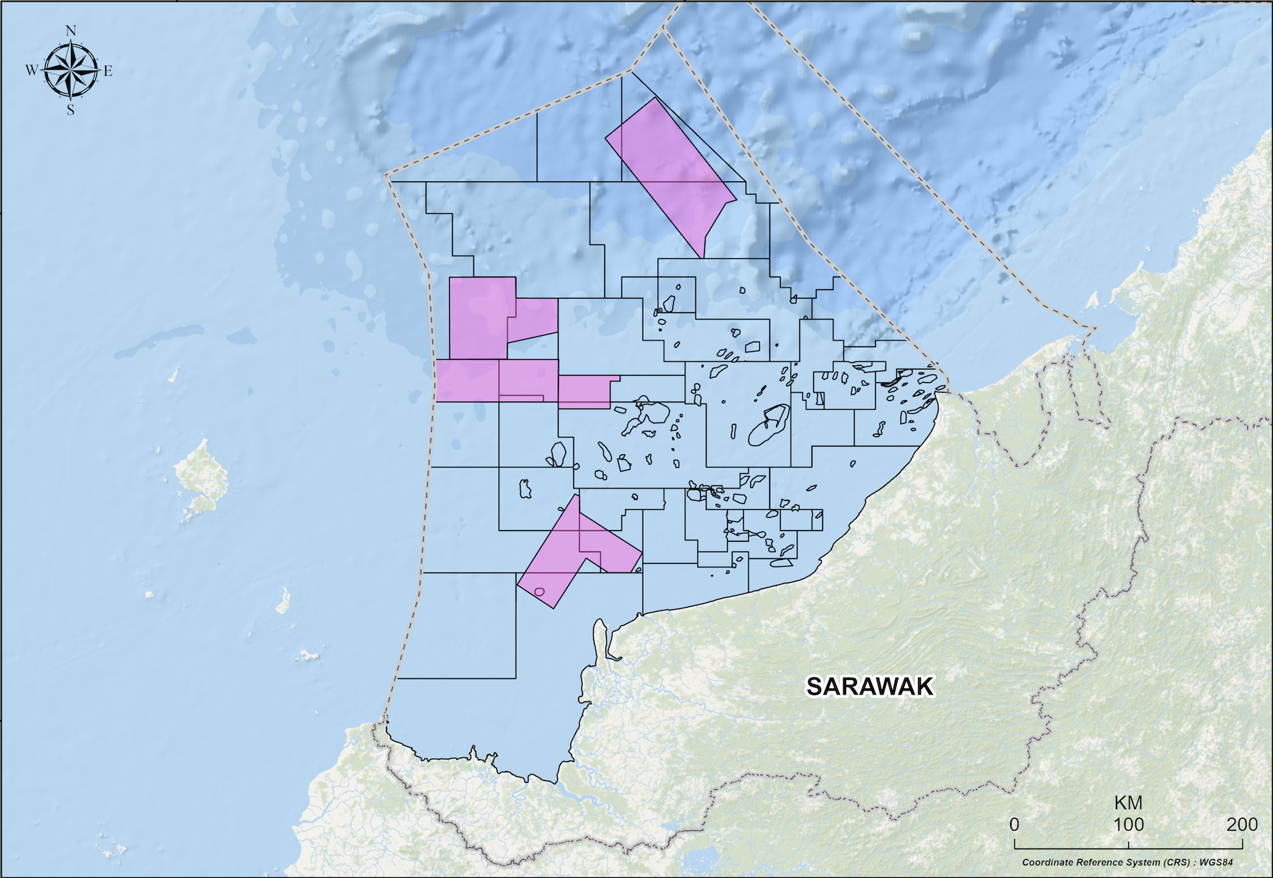
Exploration portfolio reloading is imperative to expand the HC resource base to sustain a new peak of 2 million boe/d by 2025. MPM offers open blocks to interested investors on an annual basis through Malaysia Bid Round (MBR). Currently, there are a total of 72 exploration blocks out of which 13 blocks are available for future bidding and direct negotiation.
MPM is entrusted to strategize, develop business model and promote Malaysia acreages to generate new investment opportunities and value whilst safeguarding PETRONAS and nation’s interest.
Extensive new data & studies in white space such as:
- 3D/2D multiclient and proprietary acquisition/ reprocessing seismic
- Multi-client study
- Full Tensor Gradiometry survey
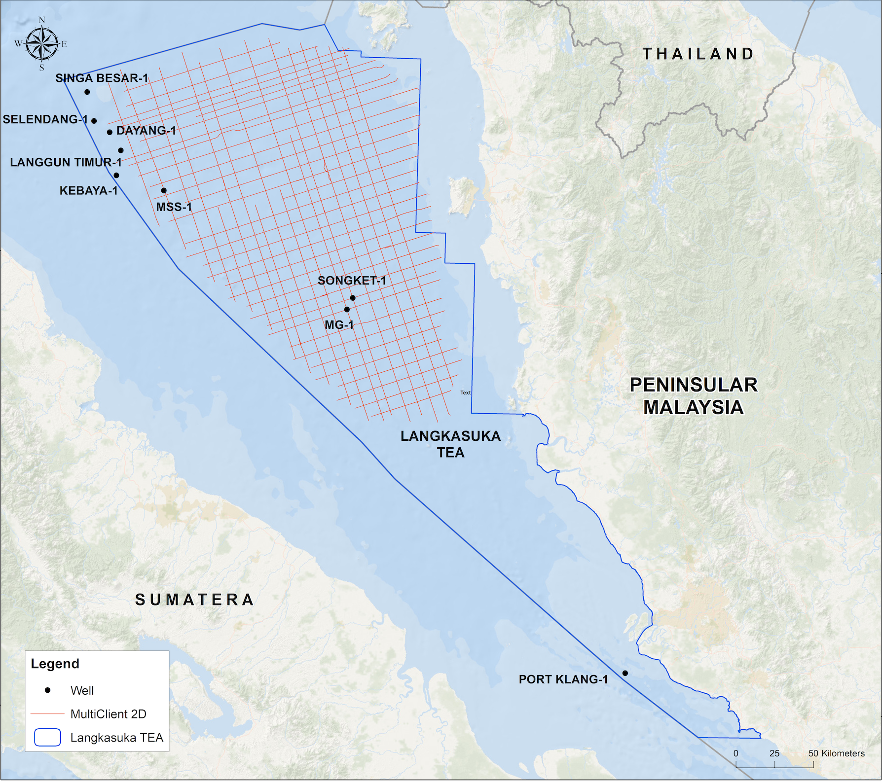
Selat Melaka MC2D
Acquisition & ProcessingMPM’s newly acquired Multi-client 2D seismic data via Veridien, employing low-frequency sources is aimed at improving the imaging of the deeper Pre-Tertiary play. The fast-track data revealed multiple tilted fault block structures and previously unseen features as compared to legacy seismic. This approach enhances seismic imaging, allowing for the identification of potential hydrocarbon traps. Structural interpretation from new 2D data validates a Pre-Tertiary fold and thrust belts. Detailed internal stratigraphy of Pre-Tertiary grabens enhances our understanding of late extensional inversion structures and their sequencing. Whilst good source rock quality and reservoir are presence based on onshore study; numerous potential traps identified from the offshore 2D seismic signify the next investment opportunities.
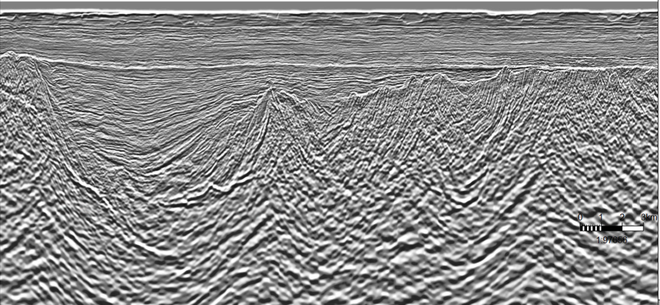
Subsurface geology structure in Langkasuka Basin
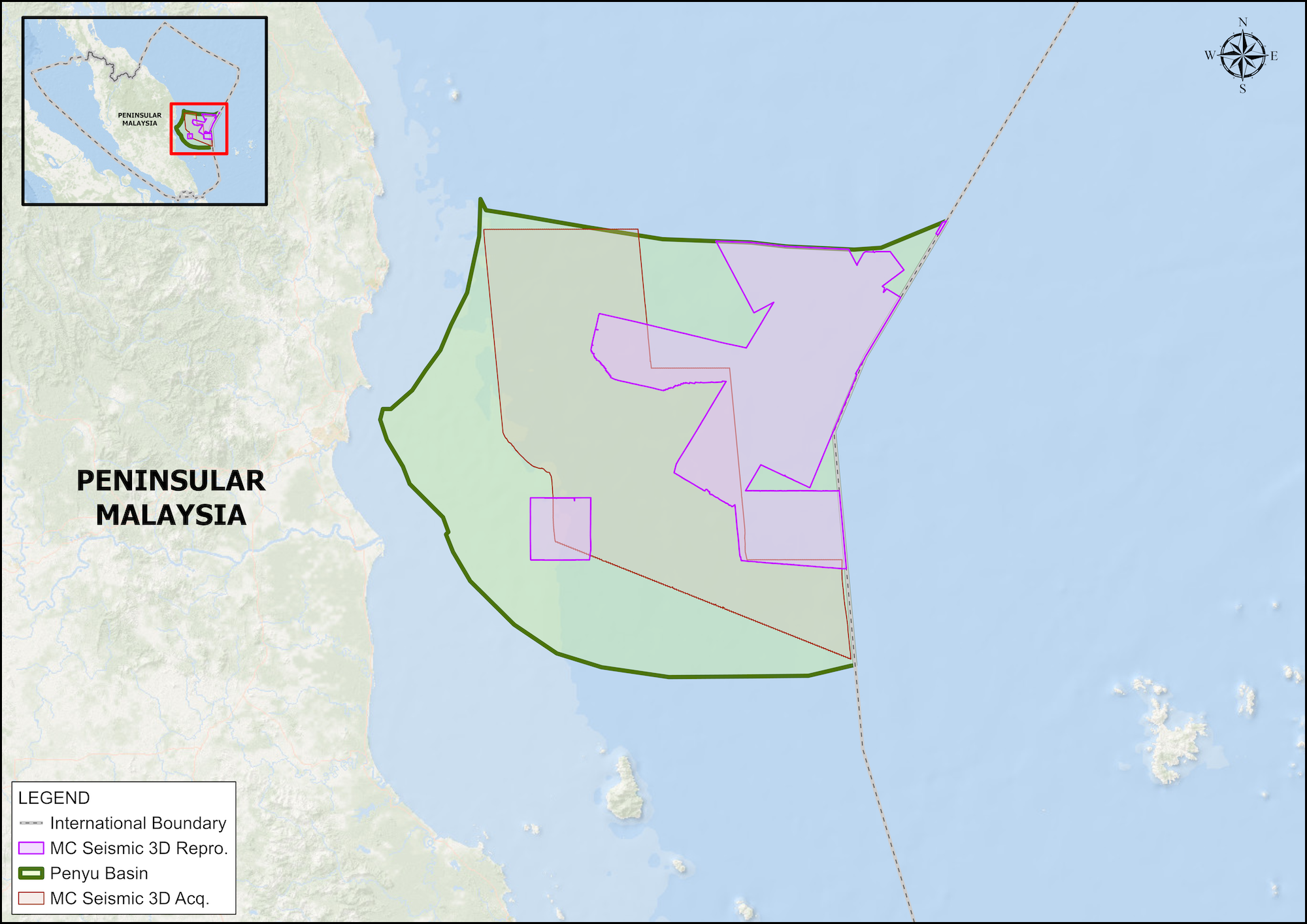
Penyu Basin MC3D
Acquisition & ProcessingPenyu Basin Multi-client 3D seismic data acquisition and processing programme via TGS and SLB is a key initiative by MPM to revitalise exploration activity in Peninsular Malaysia. This seismic programme is targeting the imaging of Tertiary and Pre-Tertiary sections, covering mainly the western side of Penyu basin. This MC3D seismic survey aspires to provide better subsurface illumination, helping investors to navigate the complexities of exploration and development phases with greater confidence and foresight.
Around 7,345 km2 seismic 3D was successfully acquired in November 2024. This new 3D seismic dataset aims to enhance Penyu Basin attractiveness with updated prospectivity and provide economic efficiency to potential investors by having ready seismic data to make an informed investment decision within fast turnaround time.
Penyu Basin MC3D PSTM (Early-out data)
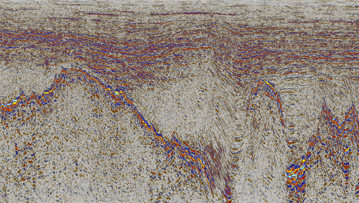
Subsurface geology structure in Penyu Basin
Malay Basin Deep
Potential AtlasThe objective is to assess hydrocarbon potential in the deeper plays, which are in the synrift section (Group, K, L & M), Pre- Tertiary Carbonate play and below producing fields for future exploration.
The study covers area from North, West to Central Malay Basin and has identified several prospects and leads within the area of interest.
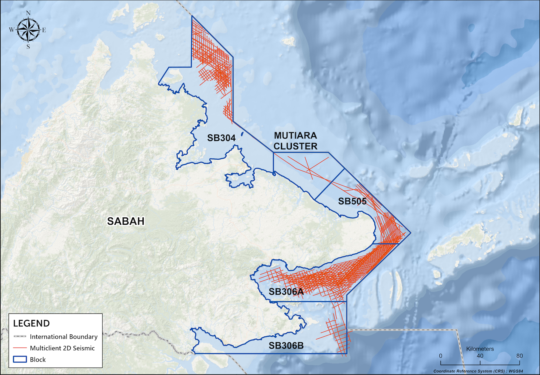
East Sabah MC2D
Seismic Acquisition & ProcessingThe aim of the East Sabah MC2D Seismic project managed by TGS is to derisk and enhance the imaging of an area that has some historical seismic data but has seen limited recent exploration. By employing modern broadband acquisition techniques and reprocessing existing data, the project will yield extensive 2D coverage with consistent imaging. This fresh data will facilitate the subsequent phase of exploration, enabling a deeper examination of compelling evidence indicating a functioning hydrocarbon system from previous wells.
The seismic lines are focused on the Miocene Sebahat formation, comprising both carbonates and siliciclastics. While some carbonate structures have been identified in legacy data, enhanced broadband imaging will aid in mitigating risks associated with these formations and provide clearer definitions of their geometries. Furthermore, employing the latest acquisition and processing technologies may uncover new leads that had not been observed before, such as the deeper mound-like feature that could represent the Oligocene-Miocene carbonate.
The multi-client approach allows for the integration of cutting-edge seismic imaging technologies, including 2Dcubed technology, resulting in a product that is broadly accessible to exploration companies, thereby maximizing the basin's potential.
East Sabah new Multi-client 2D (Fast-track PSTM) shows multiple play of Miocene Carbonate and Deeper Oligocene-Miocene.
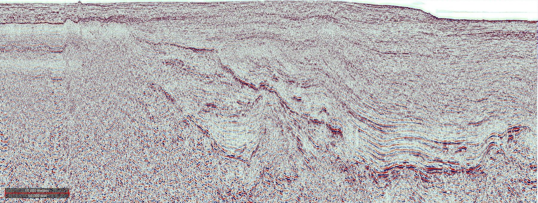
North Sabah MC2D
Seismic Acquisition & ProcessingThe North Sabah MC2D Seismic project managed by TGS and SLB is aimed is to promote the exploration of an area that has yet to be analysed using seismic data, extending beyond a well-established hydrocarbon province.
So far, exploration has primarily concentrated on the inboard fold and thrust provinces, with outboard exploration limited due to insufficient seismic data and regional comprehension. Currently, regional gravity maps identify potential half graben regions that might possess adequate syn-rift sediment thickness to serve as hydrocarbon kitchen areas, featuring intraformational reservoirs alongside fault-bound, stratigraphic closures or carbonate formations.
The newly acquired 2D seismic data spans 1,607 line-km, completed in February 2024, targeting the Late Oligocene to Early Miocene (Stage I-II) shallow water Carbonates of the Layang-Layang Basin located to the north of the Sabah Trough. By utilising the multi-client model, this initiative will enhance the visibility and attractiveness of the basin to potential investors.
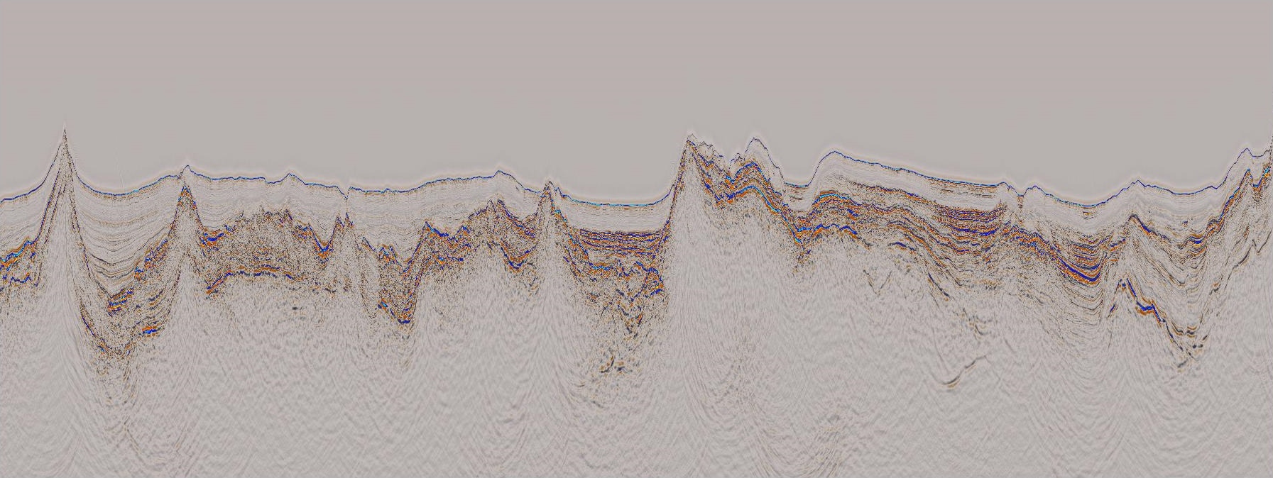
Subsurface geology structure in Layang-Layang Basin
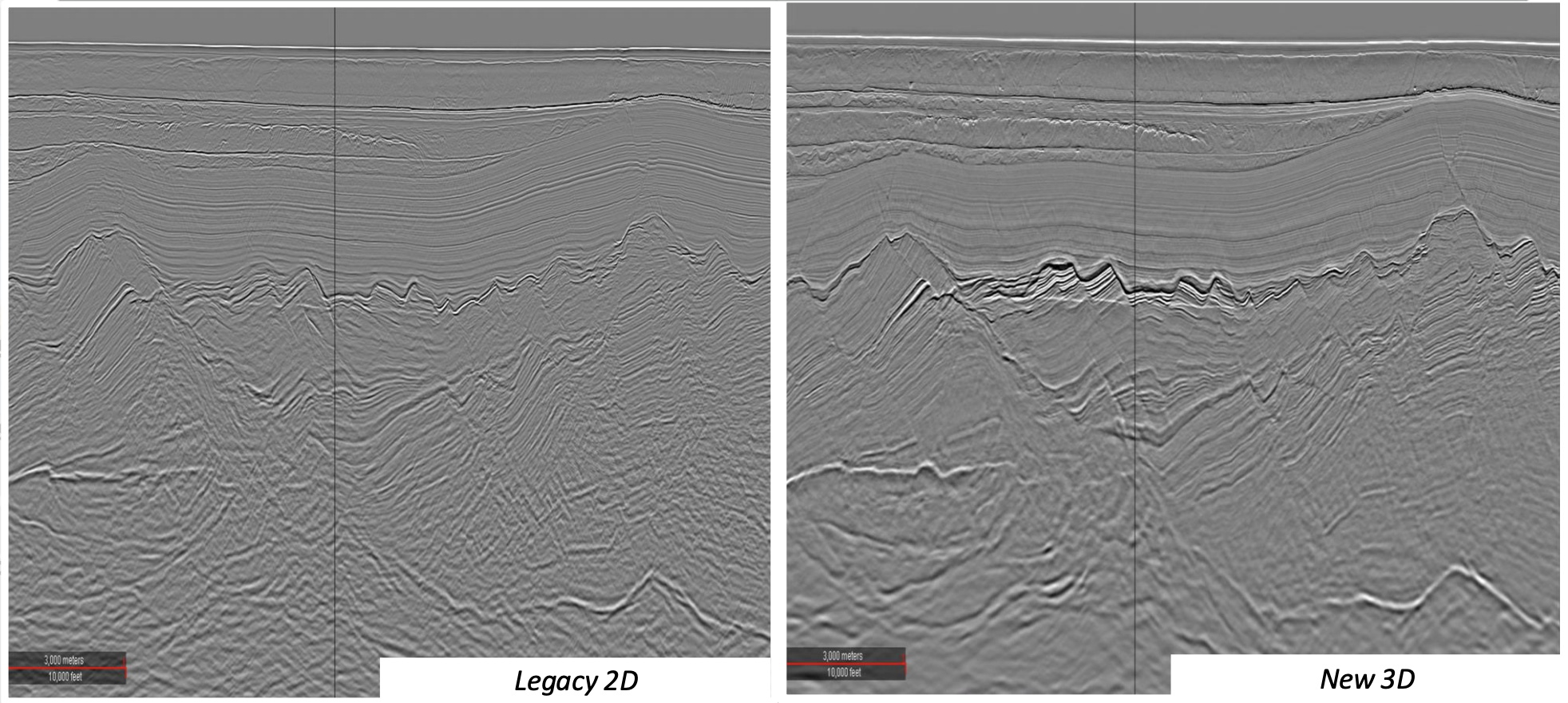
Sarawak MC3D
Seismic Acquisition & ProcessingThe study aims to create improved opportunities and introduce new play types, increase value while promoting acceleration blocks, and optimise exploration expenses. In 2019, a new multi-client 3D seismic contract was awarded for a duration of 13 years, with the first project starting in July 2021. To date, a total area of 22,400 km² has been acquired, along with some pre-funding.
INFORMATION Contract Duration
(13 Years)- Commencement Date: 29 July 2021
- Expiry Date: 28 July 2034
Area Size: - Phase 1a: 3,634 sqkm
- Phase 1b: 4,455 sqkm
- Phase 2 : 6,764 sqkm
- Phase 3a: 6,397 sqkm
- Phase 3b: 1,150 sqkm
Phase 2 Imaging Comparison
MC Study Off the Coast of west Sarawak
The objective of the study is to understand Petroleum System in West Luconia and South West (SW) Sarawak in broader perspective and to understand Tectono-stratigraphic Framework from Paleo-Rajang Delta to Bunguran Through in Pre-MMU and Post MMU.
In addition, the study results will delineate structural traps and reduce geological uncertainties for hydrocarbon exploration, focusing on key play types including Miocene and Oligocene-aged clastic and identify sweet spots area in Area of Interest (AOI)
INFORMATION Contract Duration
(10 Years)- Effective Date: 8 March 2023
- Expiry Date: 7 Mar 2033
Area Size: 86,000 km2
- Phase I: 26,000 km2
- Phase II: 60,000 km2
PETRONAS myPROdata is a one-stop-data centre introduced by MPM.
Aspiration:
A web-based platform that provides greater data access and transparency to Malaysia’s Exploration & Production (“E&P”) data. It is accessible not only to Petroleum Arrangement Contractors (PAC) and O&G companies but also to technology solution partners, researchers and academia.
Objective:
myPROdata provides a broad view of all available asset opportunities, anytime and anywhere. This enables a comprehensive and timely evaluation, which could lead to a potential investment decision. The platform provides a simple process and workflow for users to access, request, and transfer data.
Access to PETRONAS myPROdata platform is available through subscription via https://www.petronas.com/myprodata/
Our Data Coverage
Over 1,100TB
Data to exploreSubsurface Data

700,000 sqkm
3D Seismic

292,000 sqkm
Full Tensor Gradiometry

495,000 line-km
2D seismic

6,000
Wells and well logs

83,000
Technical reports
Surface Data

400
Offshore platforms

13
Onshore Terminals

>11,000 km
Pipelines

19
Floaters
Basic
For Individuals
View-only Access of Available Data
Free
- Access to explore SmartViewer & browse E&P dataset in SmartData Catalog.
- Data entitlement includes general information on Malaysian open opportunities, regional geology, cultural
- Preview of the standard and premium access level data listings in SmartData Catalog.
- This access level providers all information for the user to decide which subscription level is suitable to their needs.
- Available for a period of 3 months - free access.
Standard
Full Access of Malaysia E&P Technical Data in Open Areas
RM68,000*
- Full access to entitled data to view and download.
- Explore and customize your own web map view in the SmartViewer.
- Browse and download E&P datasets in SmartData Catalog wth detailed descriptions.
- Access to Data Visualisation to simulate the seismic view of both the 3D model and 2D seismic cross-section.
- Data entitlement includes data types of seismic & well data related to open blocks and DRO.
Premium
Full Access of Malaysia E&P Technical Data
RM89,000*
- Full access to entitled data to view and download.
- Explore and customize your own web map view in the SmartViewer.
- Browse and download E&P datasets in SmartData Catalog with detailed descriptions.
- Access to Data Visualisation to simulate the seismic view of both the 3D model and 2D seismic cross-section.
- Data entitlement includes data types of seismic & well data related to open areas and analogous producing fields and blocks for better regional understanding.
Academia
Selected Data Access of Malaysia E&P Technical Data in Open Areas
Free
- Access to explore SmartViewer & browse E&P dataset in SmartData Catalog.
- Students can explore the E&P dataset as per academic or study agreement specifications.
- Researchers have the opportunities to examine E&P datasets for potential assessment.
- Available for a period of 12 months - free access.
Bid Round
Full Access of MBR Offerings Technical Data
RM42,000*
- Full access to the selected data to view and download.
- Data entitlement includes data types of seismic & well data related to the Exploration Block, DRO and LLA which are being offered in the current MBR.
- Existing Standard and Premium subscribers are entitled to a free access to the bid round access level.
- Respective bid packages which include the bid guidelines, bid deliverables forms, PSC draft and the KYC form are also made available under this access level.
*Subscription fee is subject to 8% Service Tax regulated by Malaysian Customs.
Cultural & Metadata Seismic &
Non-SeismicWell Production Data Basic 
View List View List View List Standard >10 years post acquisition >2 years post drilling Non PSC Fields Premium >4 years post acquisition >2 years post drilling All Fields 3 months retention Academia - General
- Research
>10 years post acquisition >2 years post drilling N/A Selected data package as per approved university project proposal Bid Round - MBR
- Technical study
Bid Round data package Selected data package as per study area
Know more about PETRONAS